
Nepal Flash Flood 2026: What Happened, Trekking Areas Affected and Current Travel Conditions
Nepal's August 26 flash flood devastated the Bhote Koshi-Trishuli corridor. Here is what happened and what travelers need to know now.

On this page Collapse
Updated: August 31, 2026
The Nepal flash flood of August 26 devastated communities across the Bhote Koshi and Trishuli river corridors.
Five days later, Nepal remains in an active search, rescue, and recovery operation. The human toll has risen dramatically as teams reach previously inaccessible locations.
As of 2:00 PM on August 31, Nepal's Ministry of Foreign Affairs reported 903 recovered bodies. About 4,200 people were still unaccounted for at that time.
Those numbers may change again.
The disaster also struck an important tourism corridor north of Kathmandu. It affected access towards Langtang and the Nepal-Tibet border.
However, this was not a disaster across every trekking region in Nepal.
Understanding that distinction matters for travelers already here and those planning autumn trips.
What happened on August 26?
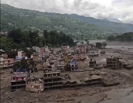
The flood struck Rasuwa District at about 8:40 AM on Wednesday, August 26. It then caused devastating damage along downstream river corridors.
Government reports describe major impacts across Rasuwa, Nuwakot, Dhading, and Gorkha. Houses, bridges, roads, hydropower infrastructure, and riverside settlements were damaged or destroyed.
The event developed with extraordinary speed.
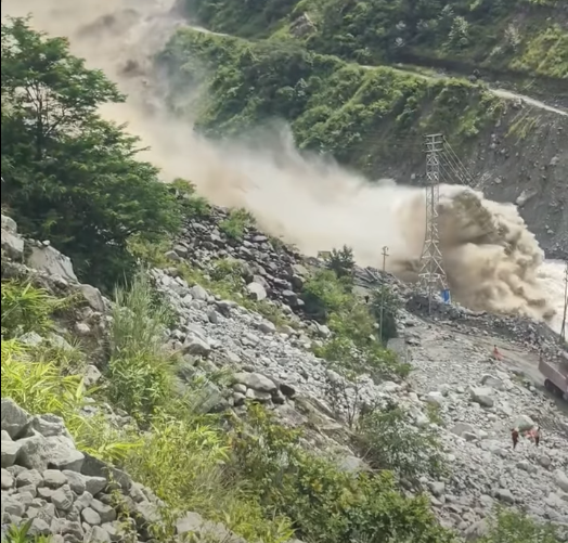
Satellite analysis examined by international scientists points towards a massive rock-and-ice collapse near the Langtang mountain range. Material entered the mountain river system and developed into an enormous debris flow.
The resulting torrent carried water, mud, rock, ice, and other debris downstream. Entire sections of the river corridor were overwhelmed.
Nepal's government initially cautioned that the exact cause had not been fully determined. That distinction remains important while scientific investigations continue.
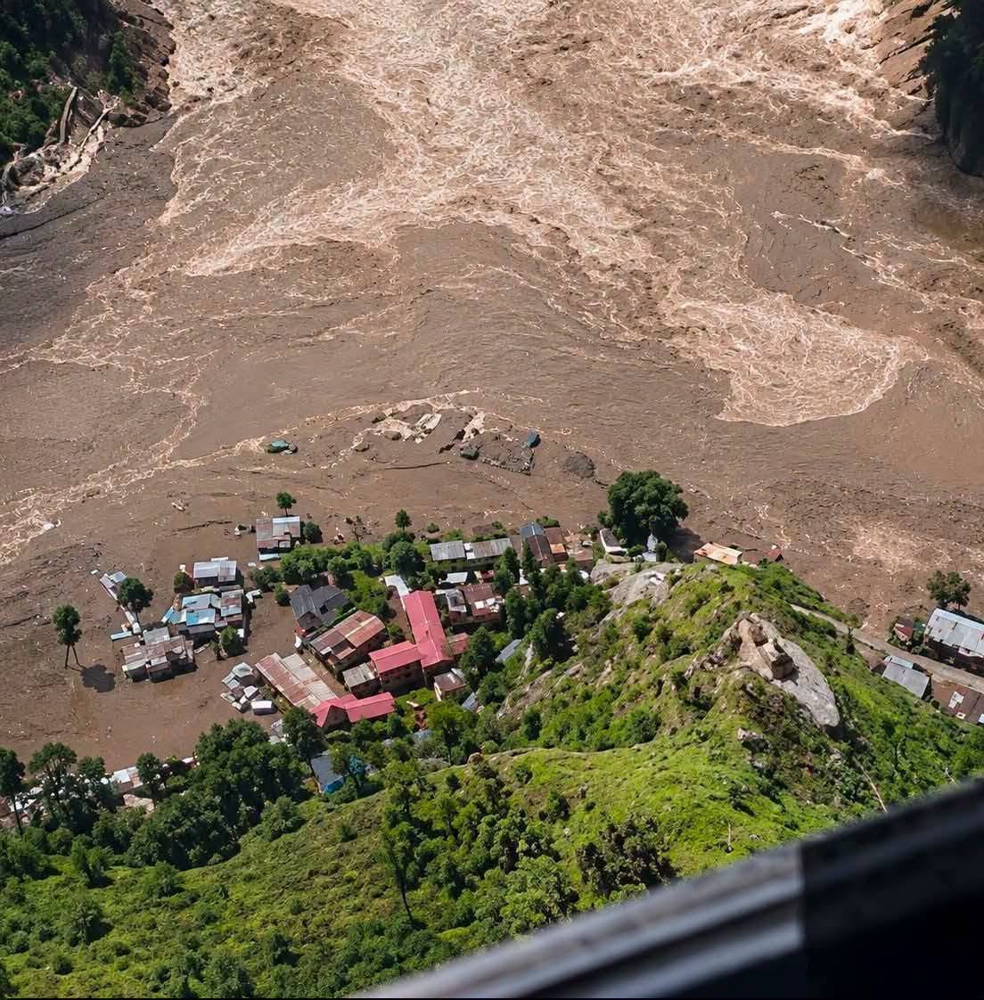
This was therefore far more than ordinary monsoon flooding.
How the disaster spread downstream
Rasuwa sits against Nepal's northern border with Tibet.
The upper river system passes through a narrow Himalayan landscape before joining larger downstream waterways. Settlements and infrastructure occupy limited space between steep slopes and rivers.
That geography increased the consequences once the debris surge entered the valley.
Rasuwagadhi and nearby areas suffered severe destruction. Timure and Syabrubesi were also directly exposed within the affected corridor.
The destructive flow continued into the Trishuli system.
Roads disappeared in places. Bridges failed. Power and hydropower facilities were damaged.
The disaster then became increasingly difficult to understand from Kathmandu.
Communications failed in some areas. Roads became impassable. Rescue teams could not immediately reach every settlement.
That partly explains why casualty estimates increased so sharply during subsequent days.
Why so many people remained missing
The number of missing people has changed repeatedly since August 26.
Early reports concentrated on visible settlements and known tourist groups. Later operations uncovered much wider losses.
Hydropower construction sites became another major focus.
On August 31, rescuers were trying to reach hundreds of workers believed trapped inside project tunnels. Heavy machinery and specialist teams were being used to clear blocked entrances.
Nepal had already mobilised around 19,000 security personnel and 16 helicopters by August 30. Specialist tunnel teams from India, China, and South Korea were also assisting.
Hundreds of foreign visitors have also been reported missing during the disaster.
Some were trekkers. Others were tourists or pilgrims travelling towards Tibet and Kailash Mansarovar.
This distinction matters when describing the tourism impact.
Not every missing foreign visitor was trekking in Langtang.
Which tourist areas were directly affected?
The clearest impact was along the Rasuwagadhi-Kerung and Bhote Koshi-Trishuli corridor.
Rasuwagadhi is an important Nepal-China border crossing. It also serves travelers heading towards Tibet and Kailash Mansarovar.
That route has been severely affected.
A trekking-industry safety update reported the Rasuwagadhi-Kerung Kailash route as closed. Alternative approaches were being considered for future travel.
The situation becomes more nuanced for Langtang.
Was the Langtang Valley Trek destroyed?
Current reporting does not support saying the entire Langtang Valley Trek was destroyed.
The main problem is the gateway and normal approach.
Syabrubesi is the traditional starting point for most Langtang Valley trek itineraries. It lies inside the badly affected Rasuwa corridor.
Normal road access through the Trishuli-Betrawati corridor has been closed.
However, TAAN's reported assessment says the Langtang and Kyanjin destinations remain safe from the direct flood impact. Gosaikunda was also reported safe from that direct impact.
That does not mean travelers should start trekking there immediately.
Access remains disrupted. Rescue operations continue. Monsoon hazards have not disappeared.
A place can avoid direct flood destruction while remaining impractical to reach safely.
That is currently the important distinction for Langtang.
What about Gosaikunda?
Gosaikunda was also reported outside the main direct destruction zone.
Its normal access arrangements are still affected by wider road disruption.
TAAN identified a possible alternative approach through Sundarijal, Chisapani, Thadepati, Ghopte, and Gosaikunda. That route could continue towards the Langtang Valley.
Travelers should not interpret that as an invitation to improvise an alternative itinerary.
Conditions can change quickly during Nepal's monsoon.
Any departure should follow current local assessments and official access information.
Ganesh Himal and Ruby Valley
Ganesh Himal and Ruby Valley were also reported safe from direct flood damage.
However, approaches relying upon Dhunche or Syabrubesi were affected.
TAAN suggested alternatives through Dhadingbesi or Arughat where appropriate.
Again, "reported safe" refers to direct flood impact.
It does not guarantee every road, bridge, trail, or local service is currently operating.
What about the Manaslu Circuit?
The Manaslu trekking region was not reported as directly affected by this flood.
Tsum Valley and the Nubri-Larke Pass area were also reported safe.
There is still an access complication.
Travelers heading towards Machhekhola and Jagat were advised against the Malekhu-Dhadingbesi approach. A bridge collapse at Malekhu affected that connection.
TAAN instead identified the Benighat-Arughat route for access.
This is another example of why regional travel information requires detail.
A trekking trail can remain unaffected while its normal road connection changes.
Were Everest and Annapurna affected?
The August 26 disaster did not directly hit most of Nepal's major trekking regions.
TAAN reported Everest, Annapurna, Makalu, Kanchenjunga, and several other regions as unaffected by this flood.
The same assessment included Dhaulagiri, Dolpo, Rara, Humla, and other western destinations.
Nepal's Foreign Ministry has also stressed that Nepal remains open to international visitors. Only specific parts of the country were directly affected.
That message needs an important qualification.
Nepal is still in the monsoon season.
Ordinary landslide, rainfall, river, road, and aviation risks can exist elsewhere independently of this disaster.
Current trekking and travel status
As of August 31, the simplest picture is:
Area | Current situation |
|---|---|
Rasuwagadhi/Kerung corridor | Severely affected and closed |
Syabrubesi | Major impact and access disruption |
Normal Kathmandu-Syabrubesi access | Disrupted/closed through affected corridor |
Langtang/Kyanjin | No reported direct flood destruction, but normal access affected |
Gosaikunda | No reported direct flood destruction, but access requires verification |
Ganesh Himal/Ruby Valley | Directly unaffected, some usual approaches disrupted |
Manaslu/Tsum Valley | Directly unaffected, road approach adjustment advised |
Everest region | No direct impact reported from this event |
Annapurna region | No direct impact reported from this event |
These conditions can change daily.
Travelers should therefore avoid relying on an old itinerary screenshot or social-media post.
What travelers should do now
Anyone currently travelling near Rasuwa should follow local authority instructions.
Do not attempt to enter closed areas for sightseeing or photography.
Travelers with upcoming Langtang journeys should contact their trekking agency before leaving Kathmandu. Confirm the road, trailhead, accommodation, communications, and evacuation situation.
Independent travelers should be equally cautious.
The existence of an alternative trail does not automatically make that alternative appropriate today.
Families searching for foreign visitors should use verified government and embassy channels.
Nepal Tourism Board has also established an information coordination mechanism for missing and rescued tourists. Tourism businesses were asked to provide verified traveler information through designated contacts.
Nepal remains open, but this region needs space
A disaster of this scale can create two harmful reactions.
One is pretending everything is normal.
The other is treating the whole country as closed.
Neither accurately describes Nepal on August 31.
Rasuwa and the Bhote Koshi-Trishuli corridor are facing an enormous humanitarian emergency. Rescue teams, survivors, and affected families need priority there.
Other trekking regions continue operating outside the direct disaster zone.
Travel decisions should therefore be based on the specific route, not Nepal's name alone.
MyTrekFinder's commitment to Nepal's disaster recovery
MyTrekFinder is still building the service that will connect travelers with trekking and tour agencies.
Paid agency services have not yet been activated.
When MyTrekFinder's paid services begin, agency payments for the first three months will go directly to Nepal's Prime Minister Disaster Relief Fund.
MyTrekFinder will not collect these service fees and donate them later.
Instead, participating agencies will make the required payment directly to the official government disaster relief fund.
The agency's official donation receipt or transaction record will serve as proof of payment for its MyTrekFinder service purchase.
Once verified, MyTrekFinder will activate the corresponding paid service for that agency.
This means 100% of the amount that MyTrekFinder would otherwise receive from these agency purchases during the first three months will instead go directly to Nepal's disaster relief effort.
There will be no additional disaster levy or donation charge imposed on agencies.
The normal MyTrekFinder service payment itself will be redirected to the Prime Minister Disaster Relief Fund during this period.
This structure also creates a clear and verifiable record. The agency pays the government fund directly, receives official proof, and uses that proof to activate its MyTrekFinder purchase.
For MyTrekFinder, the principle is simple.
The platform is being built around Nepal's trekking and tourism industry.
For its first three months of paid operation, we want the value created by agency participation to directly support Nepal's disaster recovery.
Official Prime Minister Disaster Relief Fund donation portal
A developing situation
The August 26 flood is still an active disaster.
Search operations continue. Families are still waiting for news. Roads, bridges, power facilities, and communities need extensive recovery work.
The casualty numbers in this article reflect information available on August 31, 2026.
They should not be treated as final.
For current travel decisions, use updated government information, Nepal Tourism Board guidance, and route-specific agency confirmation.
For now, the most important distinction is clear.
Nepal remains open, but the affected Rasuwa and Bhote Koshi-Trishuli corridor needs caution, accurate information, and space for recovery.
Comments (0)
Start the conversation
Share a useful question or trail insight. Every comment is reviewed before publication.
Leave a comment
Your comment will appear after an administrator approves it.